Tuesday, September 23, 2014

thumbnail

Dhaka District of Bangladesh | History and Information of Dhaka Districts

Posted by Firoz Kabir  | 1 comment

Dhaka is an ancient city which was first established in 1772. It is located at central Bangladesh and it is the economic, political and cultural center of the district and the country as a whole. It is a part of the Dhaka Division. Dhaka is the capital of Bangladesh, rests on the eastern banks of the Buriganga River which flows from the Turag to the south of the district. While Dhaka (city corporation) occupies only about a fifth of the area of this district. It shares borders with Narayanganj on the eastern part, Manikganj on the western part, Gazipur and Tangail on the northern side, Munshiganj and Rajbari on the southern part.


History of Dhaka:
In 1610 it was established as capital for the first time and named according to the name of emperor Jahangir as Jahangirnagar . Once upon a time Dhaka was ruled by the Hindu Kings. The Pala and the Sena dynasties ruled Dhaka for many years. It was not until early fourteenth century when the Muslim rulers began to come to Bengal. Dhaka was made the capital of Bengal in 1610 and Islam Khan renamed Dhaka as Jahangirnagar after the name of Emperor Jahangir. In the eighteenth century Dhaka lost political importance when Murshid Quli Khan transferred the capital of Bengal from Dhaka to Murshidabad. But Dhaka never lost its commercial importance.


Administration:
Dhaka City Corporation is now divided into two part named Dhaka north and Dhaka South City Corporation and 03 municipalities outside of city area. It has 05 upazillas (sub-district) named Dhamrai, Dohar, Keranigonj, Nawabgonj and Saver outside of metro area. The mentioned sub- districts contain 79 union Parishad, and 1863 villages.

24 Thana of this District:
  1.         Biman Bandar
  2.         Badda
  3.         Cantonment
  4.         Dhanmondi
  5.         Demra
  6.         Kotwali
  7.         Gulshan
  8.         Hazaribagh
  9.         Kafrul
  10.         Kamringir Char
  11.         Khilgaon
  12.         Lalbagh
  13.         Mugda
  14.         Mirpur
  15.         Mohammadpur
  16.         Motijheel
  17.         Pallabi
  18.         Paltan
  19.         Ramna
  20.         Sabujbagh
  21.         Shyampur
  22.         Sutrapur
  23.         Tejgaon
  24.         Uttara


Population: The last known population of Dhaka district is 1,20,43,977 (Male- 65,55,792 and Female- 54,88,185), sex ratio 119:100, Population density 8229/Sq Km, annual growth rate 3.48%.

Literacy: Literacy Rate is 70.50% and School attendance rate is 47.30% for 5 to 24 years old.

  • The post code of Dhaka is 1000 (GPO) and 1100 for Dhaka Sadar Post office. 
  • NWD code – 02
  • Total parliament seats are 20. 
  • In the liberation war period Dhaka was under Sector No 02.

Major rivers of this districts are Burigonga, Dhaleshari, Shitalakha, Bongshi, Turag, Eshamoti, Balu-Nadi etc.

Persons to be remembered of this district:
  • Nawab Sir Salimullah (Social Worker & Land Lord)
  • Atul Proshad Sen (Poet)
  • Nawab Abdul  Goni (Land Lord)
  • Nawab Ahsan Ullah(Land Lord) 
  • Kaykobad (Poet), Khaja Nazimuddin (Politician)
  •  Ranada Proshad Saha
  •  Samar Das(Singer)
  • Kali Prosanna Shingha
  •  Dr. Anisuzzaman (Educationist), 
  • Girish Chandra Sen
  • Khaja Abdul Goni   etc.


Dhakeshwari National Temple


Lalbagh fort


National Parliament of Bangladesh


Places to See:
Lalbagh fort and the tomb of Bibi Pari (1668), bara katra (1641), chhota katra and the tomb of Bibi Champa (1663), Ancient Fort and the palace of the Nawab (Jail Hospital, 1638), ahsan manzil (1872), husaini dalan (1642), Binod Bibi Mosque (1456 AD), Seven Domed Mosque (1676), Chawk Mosque (1676), Bibi Meher Mosque (1814), Armanitola Mosque (1716), Khawja Shahbaj Mosque (1679), Shayesta Khan Mosque (1664-78), Khawja Ambar Mosque (1677-78), Moriam Saleh Mosque (1706), Sitara Begum Mosque (1815), Farruk Shayer Mosque (1703-1704), Tara Mosque, Azimpur Mosque (1746), Kartalab Khan Mosque (1700-1704), Holy Rosary Church (1678), Setara Begum Mosque (1819), Bagmara Math (Nawabganj), Home stead of Raja Harish Chandra (eighteenth century, Savar), Shree Shree Sani Ashram and Math (1199 AD), Dhakeshwari Mandir (eventeenth century), Jaykali Mondir, Bahadur Shah Park, Nimtali Deuri (Asiatic Society of Bangladesh, 1765).
Read More»

1 comments:

Saturday, September 6, 2014

thumbnail

Rajshahi Division | Division Map and Information of Rajshahi, Bangladesh

Posted by Firoz Kabir  | 1 comment

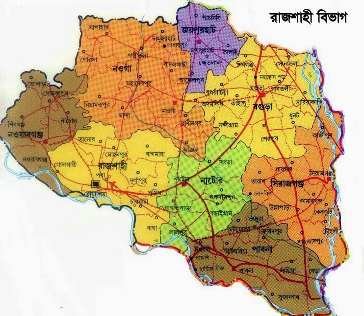
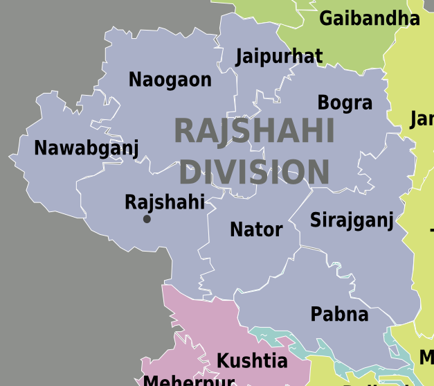
Rajshahi Division is one of the seven administrative divisions of Bangladesh. It has an area of 18,154 sq km and a population at the 2011 Census of 1,84,85,000 (male-9,25,7000, Women-9,22,8000). It consists of 8 districts, 1 city corporation, 67 Upazilas, 59 municipalities and 564 Unions (According to Govt. Web Directory). This division is characterized by its cheap labour force. It has an excellent rail and road communication infrastructure. The divisional capital of Rajshahi is only six-seven hours road journey away from Dhaka, the capital city.

Until 2010 this Division comprised 16 districts, but early in that year it was divided into two, when a new Division (Rangpur Division) was formed out of the 8 northerly districts that until then had been part of Rajshahi Division. In the mid of 1960's all the districts of Khulna Division were under Rajshahi and after dividing of Khulna Division it was formed with 16 districts. Rajshahi was dominated by various Rajas, Maharajas and Zamindars.

 Eight Districts:

  • Bogra
  • Joypurhat
  • Naogaon
  • Natore
  • Chapainawabganj
  • Pabna
  • Rajshahi
  • Sirajganj
  •  


It is in the mid western corner of Bangladesh. The famous river Padma borders it on the south and another famous river, Jamuna, lies across the eastern border. In the West, it shares a border with India. Border's districts are Rajshahi, Naogaon, Chapainawabganj and Joypurhat

Rajshahi has three large city which are Rajshahi, Pabna and Bogra. An airport was established in this division but no flight is allowed at current time.

Mango is the prime fruit of this division. Mangoes for these districts go everywhere across the nation. This division is also famous for it. Various types of mangoes are cultivated here some of them are langra, fazli, khirsa, him sagor etc.

The major educational institutes in of this division are University of Rajshahi (RU), Rajshahi University of Engineering and Technology (RUET), Rajshahi Medical College (RMC), Shaheed Ziaur Rahman Medical College, Bogra, Rajshahi College, Azizul Haq College, Bogra, Nursing Institute, Bogra,  Edward College, Pabna (under National University), Pabna University of Science and Technology, Pabna Medical College, Pabna Textile Engineering College, Pabna Cadet College, Joypurhat Girls Cadet College.

Major rivers of this division Padma , Jamuna , Boral , Pagla , Mohananda , Korotoa , Ichamati , Bangali , Chamti , Atrai , Punorvoba etc.
Read More»

1 comments:

Friday, September 5, 2014

thumbnail

Dhaka Division | Dhaka City | Capital of Bangladesh

Posted by Firoz Kabir  | 2 comments

Bangladesh has seven divisions and Dhaka is one of them. Dhaka is an ancient city across the world and was named as Dacca and the capital of Bangladesh which is located on the Buriganga River in the heart of the Bengal delta with a huge population. Approximately 15 millions people resident in Dhaka city and making it the largest city in Bangladesh and one of the largest city in the world. It is also one of the major city of South Asia. It is known as the City of Mosques, and with 400,000 cycle-rickshaws running on its streets every day, the city is described as the Rickshaw Capital of the World which makes it as the most densely populated city around the world. 

Simple History:
The old city of Dhaka became Mughal capital of Bengal in the 17th-century; during that period the city was renamed as Jahangir Nagar after erstwhile Emperor Jahangir. The city flourished as a centre of the worldwide muslin trade and attracted visitors from across the world. The modern city developed during the British Raj in the 19th-century and was dominated by the Nawabs. It served as the capital of short-lived British province of East Bengal and Assam. After the Partition of British India in 1947, it became the administrative capital of East Pakistan. It became the centre point of nationalist, civil disobedience and pro-democracy movements throughout the 1950s-60s, which culminated in the Liberation of Bangladesh in 1971.

It is Bangladesh's seat of government. It plays a vital role on the economy of the country, alongside the port city of Chittagong. The city constitutes the political, cultural and scientific heart of the nation. It is home to acclaimed national landmarks, including the Jatiyo Sangshad Bhaban, the University of Dhaka, the Liberation War Museum, the National Museum, the Shaheed Minar and the Lalbagh Fort .

In recent decades, ithas been experiencing an influx of people from across the disctricts, making it one of the fastest growing metropolitan areas in the world. The city has been attracting greater volumes of foreign investment and trade and has been witnessing the modernization of transport and communications, with the Dhaka Metro and the Dhaka Elevated Expressway under-construction. However, the city continues to face substantial challenges of congestion, poverty, overpopulation and pollution.

Division:
It is one of the most important administrative division among all divisions of Bangladesh. The capital and largest city is Dhaka. This division covers an area of 31026.51 sq km and has a population of 46,729,000 at the 2011 Census (preliminary results), revised to 47,424,418.

Dhaka Division is bounded by the Indian state of Meghalaya to the north, Barisal Division to the south, Chittagong Division on the south-east, Sylhet Division to the east, Rangpur Division to the north-west, and Rajshahi and Khulna Divisions to the west.

It is constituted with 4 city corporation with 17 Districts, 58 Municipalities, 125 Upazilla, 181 Thana, 1247 Union and 25, 244 Villages. Average literacy percentage is 62%.

17 Districts are-
    • Dhaka 
    • Faridpur 
    • Gazipur
    • Gopalganj
    • Jamalpur
    • Kishoreganj
    • Madaripur
    • Manikganj
    • Munshiganj
    • Mymensing
    • Narayanganj
    • Narsingdi
    • Netrokona
    • Rajbari
    • Shariatpur
    • Sherpur
    • Tangail

     District wise area and their population statistics are shown as here-


    Heritages of this Division:
    Ahsan Manjil
    It is located at Islampur of old dhaka on the river of Buriganga.It was used as residentail building of erstwhile Nawabs. Now It is being used as museum.

    Lalbagh Fort
    It is an ancient castle located at the centre of the capital of Bangladesh. It is established as one the historical sign of Mughal period.


    Tomb of poribibi
    Bahadur Shah Park
    Read More»

    2 comments:

      If you would like to receive our RSS updates via email, simply enter your email address below click subscribe.

    Discussion

    © 2013 Rural Bangladesh. WP Theme-junkie converted by Bloggertheme9
    Blogger template. Proudly Powered by Blogger.
    back to top